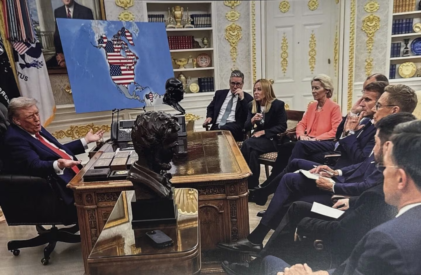
U.S. President Donald Trump stirred fresh controversy after sharing an altered image online targeting Canada, Greenland, and Venezuela. The image appeared on Trump’s Truth Social account shortly before 1 a.m. Tuesday and quickly spread across social media platforms.
The image shows Trump inside the Oval Office holding a map depicting the U.S. flag draped across large portions of North and South America. Canada, Greenland, and Venezuela appear fully or partially covered. Several European leaders stand nearby, observing the scene.
The post followed a pattern of provocative messaging aimed at close allies and strategic rivals. Observers viewed the image as symbolic rather than accidental, given ongoing foreign policy tensions involving all three regions.
Trump has repeatedly voiced interest in bringing Canada under U.S. control, referring to the country as a potential “cherished” 51st state. Canadian officials have consistently rejected such language and reaffirmed national sovereignty.
Greenland, an autonomous territory governed by Denmark, has also remained a focus of Trump’s expansionist rhetoric. The U.S. president has framed annexation efforts around national security concerns. Denmark has firmly pushed back, emphasizing Greenland’s status and self-governance.
Canada, Denmark, and the United States share long-standing ties through the NATO alliance. Diplomatic responses from Ottawa and Copenhagen have stressed cooperation while rejecting territorial ambitions.
The Trump administration has also intensified pressure on Venezuela. Washington seeks stronger influence over Venezuelan oil resources following a Jan. 3 military operation during which U.S. forces abducted Venezuelan President Nicolas Maduro and his wife.
The incident marked a sharp escalation in U.S. involvement in South America and drew criticism from international observers concerned about regional stability.
The altered image traces back to an official White House photograph released on Aug. 18, 2025. The original version showed Trump reviewing a map of Ukraine alongside U.K. Prime Minister Keir Starmer, Italian Prime Minister Giorgia Meloni, European Commission President Ursula von der Leyen, German Chancellor Friedrich Merz, French President Emmanuel Macron, Finnish President Alexander Stubb, Ukrainian President Volodymyr Zelenskyy, and NATO Secretary-General Mark Rutte.
Trump’s recent post aligns with a broader geopolitical approach outlined in the U.S. National Security Strategy released in late 2025. The document states that the United States aims “to restore American preeminence in the Western Hemisphere.”
“The United States must be preeminent in the Western Hemisphere as a condition of our security and prosperity—a condition that allows us to assert ourselves confidently where and when we need to in the region,” the November 2025 document states.
Similar map images appeared on Trump’s Truth Social account shortly before the January 2025 second inauguration, reinforcing a consistent message directed at audiences at home and abroad.